
Places + Faces, 2019
- Connor Flanagan
- Jan 5, 2021
- 16 min read
Updated: Aug 26, 2022
During the summer of 2019 our two interns, Conor and Gina, worked on various projects and events and helped to breakdown and install a new exhibit. But they also spent a lot of time digging through our collection and familiarizing themselves with our vast collection. They picked out various pieces of personal interest to them and created the virtual exhibit below originally posted to our social media accounts.
The exhibit was broken up into 5 parts each with their own specific idea behind their groupings. Enjoy!
From Big to Small: Long Island to Rogers
by intern Conor
The goal of these maps is to find a general understanding of the geography of Long Island and the locations within it. The first map will start with Long Island and each consecutive map will be a portion of the last until the final map reveals a very special location associated to the museum.
Map of Long Island - 1974


This map shows the establishment of towns on Long Island as well as some zoomed in important geographical locations. The top right map explains the process of mapping out Long Island and how many people first thought it was a part of the mainland until 1614. Also, the center right picture is of Sag Harbor being burned during the Revolutionary War as punishment for British conducting a raid on Danbury, Connecticut. It is also called the Meigs Raid and saw six loyalists killed, ninety captured, and zero casualties on the American side. During 1777, the British controlled New York and Long Island while the American Continental Army surrounded the city with forces in northern New Jersey and southern Connecticut. As a result, the Long Island Sound was used by both sides a way to attack each other.
Map of Suffolk County - 1858


This is a map of Suffolk County from 1858. This map shows us all of the towns but also some the biggest settlements in the county. For example, Sag Harbor is the biggest settlement shown, most likely because it was one of the most significant locations in the county. It was a major whaling port that peaked during the 1840s. It was also a location where people went to be sailed around South America for the California Gold Rush in 1849. The map also provides the names of owners at the time. Many of those families still hold land today such as the Halsey family in Southampton.
Map of Southampton Town - 1873


This is a map of Southampton Town in 1873. What is unique about this map is some of the changes in Southampton town since its creation. One thing to look at is the hamlet Good Grounds. You might say that it no longer exists, but we actually know it today as Hampton Bays. The reason for the change of names was because many people who wanted to visit the Hamptons but could not afford to, went to Good Grounds instead. Eventually, they called for a renaming of the hamlet and were able to out-vote those who wanted to keep the name as Good Ground (mainly permanent residents). The name was officially changed in 1922.
Map of Southampton Village - 1873


This is a map of the village of Southampton in 1873. The map shows owners as well as some locations such as the Presbyterian Church as well as the cemetery. The reason churches are some of the first buildings marked on the map is because they are some of the first buildings created in each town. They were usually the tallest building in the town as well, showing the importance religion had to the people. Across from the church we can see the property owner is Mrs. A. Rogers, the woman who was one of the many owners of the Rogers Mansion. We can see that some things have changed since then such as Town Pond now being called lake Agawam. We can also see above the cemetery is a school that does not exist and the Elementary school on Hampton Road today is the I. Sayre Estate.
Blue Prints of Rogers Mansion property - 1926


This map shows the location of the Rogers Mansion in 1926. What is significant about this is that Rogers Mansion was actually on Main Street before it became a museum. The Mansion was moved back from Main Street to its current location in the late 1920s. We get an inside look to the original state of the residence by seeing the property having multiple gardens, a place to dry clothes and even a fountain. If you were to visit the museum today, some notable changes would be the installation of small buildings around the mansion that are from all over Southampton Town and make help tell the full story of Southamptons rich history.
From Farms to Fame
by intern Conor
These maps will be specific to The Hamptons. The goal of this section is to show how the Hamptons became the Hamptons that we know today. To accomplish this the maps that will be exhibited will start depict the Hamptons in the 1600s and will chronologically advance to today. Particular attention should be paid attention to the maps of the early twentieth century where the Hamptons began to explode.
William S. Pelletreau map of Southampton Main Street - 1878


This map was created by William S. Pelletreau in 1878. The map shows the owners of property on Main Street from 1648 till 1878. Many familiar names can be found such as Pelletreau himself, Halsey, Sayre, Rogers and more. What is interesting is that the records start at 1648 instead of 1640, the year Southampton was founded. This is most likely due to the Main Street we know today was not the Main Street when the village was first established. The original settlers started at the head of the town pond, but would eventually move Main Street to its current location.
Map of Bridge Hampton - 1900


This is a map of Bridge Hampton in 1900. It shows us many interesting things such as the owners of the properties at the time. Once again, many well-known names are on the map such as Corwith and Halsey. The map also shows us some of the buildings at the time such as the Presbyterian Church and the Bridge Hampton Creamery. It is also interesting to see that what looks like a major road on the top half of the map is actually the railroad and Main Street is on the bottom half of the map. Another thing many of you probably noticed is how Bridgehampton is spelled on this map. Many towns like Bridgehampton have had various differences in spelling over the years and at the time this map was created, it was done as two words. Do you know when it started to be spelled as one word?
Map of Southampton with aerial photos - 1927


This map is an aerial view of Southampton in 1927. This was most likely used in a newspaper in New York City to attract people to visit Southampton. The smaller map in the bottom right corner shows how to travel to Southampton from Manhattan. This can be seen as another lure to go to Southampton because the map comes with directions. What is also interesting is the reason the route goes through southern Long Island instead of the middle is because the Long Island Expressway would not be constructed for several decades. The road they would use was Montauk Highway which ran from Queens all the way to Montauk. The main map highlights notable landmarks in Southampton that no longer exist or have changed. An example would be the Southampton High School which is now the town hall. Also, a large portion of Hampton Road is open land, but would later become the Southampton Elementary School, the largest building in the village. Lastly, Rogers Memorial Library is on Jobs Lane in 1927 but would later move to its current location on Coopers Farm Road. The former building still stands today and even though it is no longer used as a library, it still has the original library title on the building.
Historical Tour of South Fork - 1932


This map is a historical tour of the South Fork in 1932. The map shows the tour route that allows visitors to view landmarks across the Hamptons. Each landmark is listed and the year of creation is given such as the Rogers Memorial Library in 1895. This was another way for tourism to boost in the Hamptons and hopefully have these same tourists return. Even though this period was during the Great Depression, the Hamptons was still an attractive location for those who were still capable of going on vacations and spending money.
Profiles of Southampton
by intern Gina
The third section of this online exhibit, Places + Faces, moves now into the faces category. The aim of this exhibit is to explore prominent residents of Southampton across two centuries of the town’s history. The focus will be placed on the historical residents of Southampton and their individual impacts on the heritage of the town. Topics that will be explored will include the whaling industry and its importance in Southampton as well as the prominent families whose' names have remained essential to the understanding of the town’s heritage. Particular attention may also be placed on the artists and their specific connection to the works.
Captain James Rogers by Frederick R. Spencer, 1833


This portrait painted in 1833 by Frederick R. Spencer is Captain James Rogers, son of Captain Jeremiah Rogers of Southampton, NY and Hyde Park, NY. Jeremiah is notable for having crossed the ocean sixty times in his own ship and would eventually pass away in the West Indies. His son is portrayed in the portrait with large sideburns, a starched high collared shirt, and black cravat representing mens’ fashion in the 1830’s.
Mary Halsey Rogers by Frederick R. Spencer, c. 1850


The young lady in this portrait by Frederick R. Spencer is of Mary Halsey Rogers (1839-1919), daughter of Captain Albert Rogers and Cordelia Halsey. It is possible that this portrait was from a collection of the New York Historical Society. The piece may be from 1850 due to the style of Mary’s white dress with a pink rosebud at the collar.
Frederick R. Spencer’s work is memorable for his smooth, linear style. His later works appear almost photographic due to the high degree of finish. Spencer became interested in portraiture at an early age after seeing an exhibition by Ezra Ames in Albany at the age of 15. In 1825, Spencer would travel to New York City to draw from the casts at the American Academy of Fine Arts. He would later become a well revered portraitist for New York’s most prominent residents.
Astelle Atterbury


Astelle Atterbury was the elegant wife of esteemed Architect Grosvenor Atterbury, who designed iconic houses in Southampton and beyond. Astelle is portrayed in a slick black dress, but interestingly posed in a dress with feathers and beads that took a peacock form. Astelle did not think the dress would look good in the painting, and had a tussle over it with the artist. As you can see, Astelle won, as she is believed to have threatened to walk away from the painting if she did not get her way. In her later years, Astelle secluded herself in her home on Sugarloaf, a “hill” in Shinnecock Hills. Her appearance in her latter years of her life would shift, and be quite different from her past socialite facade, as she grew to love her jeans and checkered shirts and was often found in her beloved tractor.
James Parrish and Family


This is a photograph of James Parrish, brother to Samuel Parrish, founder of the Parrish Art Museum and the final private owner of the Rogers Mansion. There is reason to believe the photograph was taken at Old Town Pond in Southampton. Parrish’s family is seen ice skating around him, and have brought the old man to the frozen pond to enjoy some time on the ice. The photograph is quite fun and lighthearted, depicting the Parrish family in a whimsical setting. Ice skating was a popular recreation for people during the early 20th century during cold winters, just as it is today.
Samuel L. Parrish

Samuel Parrish, founder of the Parrish Art Museum and final private resident of the Rogers Mansion, was born into a prominent family of Philadelphia Quakers. He developed a taste for Italian Renaissance artwork as a student at Harvard College. After moving his successful law practice from Philadelphia to New York in the early 1880s, Parrish began collecting art seriously. During this time, he would visit his family home in Southampton more regularly and in 1896, after visiting Italy, Parrish began his endeavor to build an art museum in Southampton that could store his prized collection of Italian Renaissance art. The Parrish Art Museum would grow into one of the best art museums in the area today thanks to Parrish’s commitment to the preservation and celebration of art.
Katherine Sullivan Meehan by Natalie Johnson Van Vleck


This portrait, made in 1946 depicts Katherine Sullivan Meehan, member of the New York and Southampton’s Irish aristocracy in an elegant demeanor. She served on boards at St. Vincent’s and Southampton Hospitals and often held fundraisers in her and her husband’s home, “Adare” on First Neck Lane. Mrs. Meehan was also a member of the Southampton Garden Club.
The artist, Natalie Johnson Van Vleck, was an early modernist painter, whose had works exhibited all across the country. Notably, her portrait of the then president-elect FDR is among the portraits of NY’s governors at NYS Historical Association. Van Vleck was also an heiress as her father developed the formula for Palmolive Soap, and spent her summers as a child at “Ballyshear” (currently owned by Michael Bloomberg). Van Vleck was also a talented metal and woodworker, with several of her paintings still bearing their handmade frames.
Rev. Samuel Herrick by Unknown, 1900


This Portrait of Rev. Samuel Herrick was completed by an unknown artist in 1900. Herrick, a well-regarded minister in Boston, came to Southampton in 1890 to speak at the 250th anniversary of the founding of Southampton. In his speech, Herrick spoke about the importance of building a structure to store the Town’s historical records, as well as to have a place for people to take pride in the preservation of their hometown history. Shortly after, the Southampton Colonial Society (now known as the Southampton History Museum) was founded in 1898. We may have Herrick to thank for the existence of our museum.
Pyrrhus Concer by Pfaffenbictcer, 1997


The legendary whaler Pyrrhus Concer was born on March 17, 1814 to his enslaved mother, Violet. Concer lived the first part of his life as an indentured servant to the Pelletreau family and when he eventually gained his freedom as a young adult, Pyrrhus began down the road to his successful career as a whaler. His most legendary venture was when he was aboard the Manhattan in 1846 when the crew rescued 22 shipwrecked Japanese sailors and decided to bring them home to Tokyo, then known as Edo. This was dangers because at the time Japan did not allow foreign ships to enter their waters but they were able to dock in Tokyo Bay, return the sailors home, and Pyrrhus was one of the first African Americans to visit Japan. Later in life, Concer bought a home on Pond Lane in Southampton where he started a ferry company which transported people across Lake Agawam from the Village to the beach. Concer also was a regular attendant at the First Presbyterian Church in Southampton, across from the Rogers Mansion. Concer’s gravesite, at the Old Town Burying Ground, has engraved the words: “Though born a slave, he possessed those virtues without which kings are but slaves”. These impactful words that illustrate Concer’s moral admiration are beautifully mirrored in this work. The artist, Pfaffenbictcer, created the work rubbing charcoal on Pyrrhus’s grave.
Captain George White


This portrait from 1875 is of Captain George White (1823-1893). At a young age, White worked as a cabin boy, whose duties included waiting on ship officers. Later in life, White was credited with daring rescues from shore, saving crew members from shipwrecked vessels while sailing aboard the bark (a sailing ship of three or more masts) Cadmus. White later entered politics and would serve as President of Town Trustees as a member of the Democratic Party. White’s naval adventures illustrate the tremendous heritage of the whaling industry in Southampton.
Native Americans by David Bunn Martine, 2007


This is a depiction of Native Americans by David Bunn Martine, painted in 2007. Martine was born in Southampton, NY in 1960 to his Shinnecock and Mohawk mother, Marjorie, a classically trained opera singer, and father Thomas Siklos, a Hungarian music director, organist, and voice teacher. Martine grew up surrounded by an artistic family and gained a deep appreciation for his Shinnecock culture after living on the Shinnecock Indian Reservation. His artwork largely depicts Native Americans in traditional dress and pays homage to his rich Shinnecock and Apache heritage. Martine’s artwork teaches us to appreciate and respect the heritage of the Shinneock, which spans over 10,000 years in Eastern Long Island. Today, Martine continues to share his love for art and culture as a curator for the Shinnecock Nation Cultural Center and Museum in Southampton.
Our Collection beyond the Sound
by intern Conor
These maps will showcase the collection of the Southampton History Museum and how our information stretches beyond the town lines. Some maps could show whale routes across the globe and other maps could be of Long island but from the English perspective during the Revolutionary War.
Map of Long Island - 1779


This is a map of Long Island in 1779. This is also an English map which is significant because the English in 1779 were fighting the Americans in the Revolutionary War. Of course, there are a lot of differences between this map and Long Island today. An example would be that Nassau County does not exist but Queens County is double the size. Also, East Hampton is written down as East Hampstead. Lastly, according to this map, the Long Island Sound is also called The Devils Belt.
Mysterious Map


This map is very interesting because we are unable to determine what location the map is showing. One possible idea for the use of this map was for whalers. The anchors could be markers for where they went to shore since all of the anchors are on the coast and none out on the water. The dotted line could be the route used by the whalers to find whales since the dotted line is farther away from the coast most likely where any whales would be. Lastly, the numbers could have been used to determine the depths of certain parts of the water. This would make sense in the cases where the numbers are located near the anchor markers to help the sailors avoid beaching the ship. The numbers are also seen in two areas in straight lines. These are at two straights where the sailors could need to sail towards one side of the water is at low tide.
Map of Southern African Coast - 1854


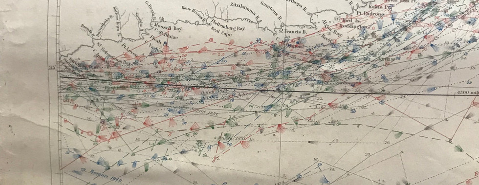


This is a map of Southern Africa in 1854. It was created by the United States Hydrographical Office. The goal was to show the currents and the winds as they change through the seasons. The key gives a very detailed description where a shorter brush stroke can stand for a light breeze instead of a fresh breeze. This incredible attention to detail is most likely due to many people using sail boats to navigate the seas. Although steam ships were around during this time, sail boats were still used throughout the 1800s. Also, the map was most likely created for not only government ships, but merchant ships as well.
Map of Arctic Ocean - 1835


This is a map of the Arctic Ocean in 1835. We also believe that it was created by the British because it says the map was created by an act of Parliament. Another interesting thing to see is that North America is incomplete. Greenland is also missing a northern portion most likely due to people not trying or unable to travel that far north. Also, Alaska was a part of Russia during this time. I was not until 1867 that the United States would purchase the territory from Russia for $7.2 million.
World Map showing Whaling Voyages


This map shows three different whale voyages conducted from Southampton in the 1800s. The Whale voyage conducted by Mercator Cooper from 1843-46 actually visited Japan. It was one of the first American voyages to enter the country and Pyrrhus Cypher who was on board the Manhattan, was one of the first African-Americans to travel to Japan. Pyrrhus was born an indentured servant on March 17, 1814 but would gain his freedom in his late teens or early twenties. He would become a whaler and it was his third voyage aboard the Manhattan that would bring him to Japan.
The Rogers Mansion’s hidden gems
by intern Gina
The Rogers Mansion houses a wide array of artifacts, each connecting to Southampton in different ways. This exhibit will focus on interesting artwork that is on display around the Rogers Mansion and can be seen anytime you visit the museum. At first glance, the artwork may seem unrelated to each other, but together they illustrate the rich heritage of Southampton. This exhibit is designed to give a brief insight on the artwork in the museum so that visitors to the museum can gain a deeper understanding as to why the artwork is on display, as well as what makes these particular works worthy of a viewer’s attention.
Salon Style


While artwork is usually the focal point of an exhibit, picture hanging is an art form in and of itself. The Salon style picture hanging can be seen throughout the Rogers Mansion, such as in the Dressing Room. In the Dressing Room, this style is portrayed with mismatched picture frames, hanging in a seemingly haphazard way. The historical context of this style comes from late nineteenth century France when the idea of hanging art differently came into fashion. In the Salon de Paris, an annual Parisienne art show that exhibited the most prestigious artwork in Europe, art hanging would come to represent hierarchy with the works of more important artists hanging lower. When Impressionist artists came into the public eye, they understood the “value” of the salon, but believed that art was about being “seen”, not so much about reputation or status. Salon hanging would remain a popular style for museums and homes. The dressing room in the Rogers Mansion would be a retreat for Clara Parrish away from the masculinity of the rest of the house and the salon style reflects the feminine nature of the room.
Copy of Sanctuary


This painting is by “Abbrylev” and is a copy of a painting titled “Sanctuary” by Heinrich Sperling, a well-known German dog painter. Sperling notably painted the relationships between animals, often in naturalistic and comedic settings. The interaction between the dogs is thought to have been intended to compare the attitudes of various breeds. Here, the terriers aggressive and energetic nature contrasts the calm and protective St. Bernard.
The practice of copying historically important paintings was popular in the leate 19th and early 20th centuries. Tourists often bought copies of paintings as souvenirs. Here, the signature on the back of the painting is cryptic. This may have been done on purpose, as Sperling was still alive at the time the copy was made, distancing the original from the copy. When viewing the painting at the museum, do compare ours to the copy and mark the differences, such as the kitten’s collar,range of the scene, and the color of the St. Bernard’s.
Sail of the Mayflower


Before the Pilgrims arrived at Plymouth Rock in Massachusetts, they set sail from Southampton in Southwestern England, in 1620 aboard the Mayflower which consisted of 25 members of a radical Puritan faction known as the English Separatist Church. After it illegally broke from the Church of England in 1607, the Puritans settled in the Netherlands. When economic difficulties and the fear of losing their English culture hit, the Puritans began their plan to settle in the Americas. Southampton, England is a reminder of the origins of its sister city across the pond. Interestingly, Southampton, NY was founded by pilgrims who left Massachusetts shortly after landing at Plymouth Rock.
King Cole


This is a smaller version of the original mural by Maxfield Parrish, cousin to Samuel Parrish, founder of the Parrish Art Museum and final private resident of the Rogers Mansion, in the King Cole Bar in the St. Regis Hotel in Midtown Manhattan. The mural was originally commissioned by John Jacob Astor IV in 1909 in his Knickerbocker Hotel. Parrish, unsure about doing the painting due to his non-drinking Quaker upbringing, ultimately agreed when Astor raised the price to $5,000, which would be roughly $140,700 with today’s inflation. In 1932, the Parrish mural was installed in the hotel. Samuel Parrish was fond of his cousin’s work and commissioned a smaller version to be placed in his home, where it has remained in the same spot in the Rogers Mansion ever since.
The Belle of Scio


This image is “The Belle of Scio”, a 19th century Photogravure by Goupil. A Photogravure, which is an image produced from a photographic negative, that is transferred to a metal plate and etched in. There are two beautifully dressed ladies in classical garments gazing out over the sea.
The Rogers Mansion itself is a Greek-Revival structure. The Greek influence can be seen in many of the Greek inspired works of art, such as this one, in the museum, as well as on the exterior of the building. The columns in front of the Rogers Mansion are Ionic pillars from the Classical order of Greek architecture.